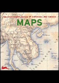
Historical and Curious Maps
Knihu kúpite v
1 e-shope
od
24,91 €
Ak sa vám po kliknutí na tlačidlo "Do obchodu" nezobrazí stránka knihy vo vybranom e-shope, je potrebné vypnúť AdBlock vo vašom prehliadači pre našu stránku.
Návod na vypnutie je napríklad na adrese https://www.sme.sk/dok/20466299/ako-vypnut-adblock-na-sme-sk-whitelist.
Krátky popis
This book contains stunning images for use as a graphic resource,
or inspiration. All the illustrations are stored in high-resolution
format on the enclosed free CD-ROM and are ready to use for
professional quality printed media and web page design. The
pictures can also be used to produce postcards, or to decorate your
letters, flyers, etc. They can be imported directly from the CD
into most design, image- manipulation, illustration,
word-processing and e-mail programs, no installation is required.
For most applications, single images can be used free of charge.
Please consult the introduction to this book, or visit our website
for conditions. This is a book showing how curious maps can be, and
how beautifully they can be executed. The selection is of great
diversity in appearance and meaning, there are comparative
overviews of the length of rivers and the height of mountains,
nautical charts, medieval city plans, and maps from pre-historical
times. Also included are historical schemes showing how to make and
read maps, and maps with a double meaning. Historical &,
Curious Maps contains a collection of amazing and beautifully made
maps that have been chosen on visual impact and uncommonness. The
selection is of great diversity in appearance and meaning, there
are comparative overviews of the length of rivers and the height of
mountains, nautical charts, medieval city plans, and maps from
pre-historical times. Also included are images of how Europeans
perceived the world to look like many centuries ago, highly
detailed bird’s-eye maps from Japan, and archaic, captivating
charts made by Native Americans and Australian Aboriginals.
Furthermore, there are a number of very extraordinary maps with a
double meaning. Of some maps, details are shown in the book. The
CD-ROM, however, contains all the maps in full.
Výber kníh autora
neuvedený autor


Zobraziť všetky knihy autora
neuvedený autor
Výber kníh vydavateľa
Slovart
Zobraziť všetky knihy vydavateľa
Slovart
Naše tipy